Length: 9.6 Miles round trip
Elevation Change: 2300' Elevation gain
Season: Summer thru Fall
Difficulty: Challenging
Permit: NW Forest Pass Required
Features:
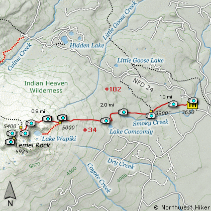
This hike follows Trail #34 off the
Forest Road #24. You will hike through
fairly dense forest as the trail begins
to increase in steepness. At about
a mile you will come to a junction of
Trail #102. Keep straight ahead as you
enter the Indian Heaven Wilderness.
The trail becomes much steeper and you
will encounter a few switchbacks. You
can get an occasional glimpse of Mt
Adams as you make your way up some of
these switchbacks. At about 3 miles
you will come to the junction with
Trail #34A that goes to Wapiki Lake.
Bear right and keep climbing steeply
toward the ridge above the lake.
As the trail nears the summit of the
ridge above Wapiki Lake, you will be
able to enjoy some of the best vistas
in the entire wilderness. Mt Adams
is to the northeast, Mt Hood is to the
southeast, and Wapiki Lake is directly
below you.
The trail begins a slow descent as it
nears the base of Lemei Rock. On this
CD Guide I do not describe how to
climb the rock. Rather, I depict hiking
up to its base and ridge line which is
just northeast of the peak itself.
From this easily accessible ridge line
you can enjoy views of Mt St Helens to
the west, Mt Rainier to the north,
and Mt Adams to the northeast.
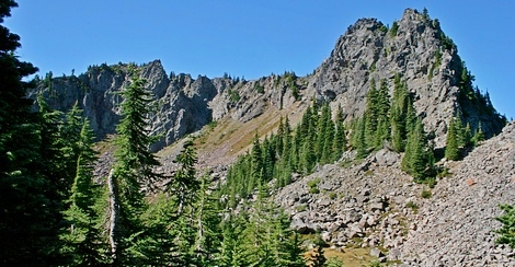
Lemei Rock
|
How to get there:
NEW!
Click for PDF Directions Map of this Hike
From Portland, OR
From Portland, travel east on Interstate Hwy 84 to Exit 64 at Hood River.
Turn left, and pass under the freeway and cross the toll bridge ($2.00)
into Washington state. Turn left onto SR14 and drive approximately 1.5
miles to state road 141 Alt. Turn right onto SR141 Alt. and follow it another
2 miles and merge bearing left onto SR141. Then travel north on SR141
for another 19 miles to Trout Lake and the junction to Mt. Adams Road,
which heads north to other hike destinations.
from Trout Lake, WA
Bear left and continue on SR141 westbound out of Trout Lake for about
5.5 miles and you will cross into the Gifford Pinchot National Forest
and the road changes to Forest Road 24. Continue westward on FR24 for
another 2.5 miles and you will come to the junction where FR24 turns
north. Turn right and continue to follow FR24 north for another 5 miles
and you will pass the trailhead for Wapiki Lake and Lemei Rock.
|