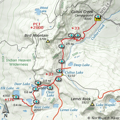
Length: 8.6 Miles round trip
Elevation Change: 1700' Cumulative Elevation gain
Season: Summer thru Fall
Difficulty: Challenging
Permit: NW Forest Pass Required
Features:
Here is another outstanding hike in the
Indian Heaven Wilderness. The hike begins
at the Cultus Creek Campground off Forest
Road #24. The trail is very steep right
out of the gate and continues that way
for about a mile. There are some well
placed switchbacks that make the elevation
gain quite tolerable. Most of this
part of the hike is in dense forest.
At about a mile, at the corner of one
of the switchbacks, you will come out
onto an opening with absolutely incredible
views of Mt Adams, the Goat Rocks, and
Mt Rainier. Then its back into the forest
for another mile. As the trail gains
elevation it is more and more in the open.
At about 2.25 miles you will come to the
junction of Trail #33A which leads to
Deep Lake.
Continue on straight ahead passing
Cultus Lake to your left. The trail
reaches its highest point just past
the lake at the junction to Trail #34.
Keep straight ahead on Trail #33 as
you begin to lose elevation.
In about a half mile you will pass
the junction to Trail #179, and then
you will come to Clear Lake. After
this lake you will come to the junction
of the Pacific Crest Trail (PCT #2000).
Bear left and follow the PCT south.
Soon you will pass Deer Lake on your
right. It is just a short walk to the
lake, then back on the trail. In about
a half mile you will come to the junction
of Trail #176 which leads to Elk Lake.
Bear right and follow this trail past
Bear Lake. If you have time, explore
the north side of the lake before
returning to the trail and heading for
Elk Lake.
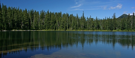
It is only about a half mile to Elk
Lake. The trail is basically level
and mostly in dense forest. When you
arrive at Elk Lake take time to
explore the south and western shores.
Return to the trail head via the same
route you used to get to Elk Lake.
Elk Lake
|
How to get there:
NEW!
Click for PDF Directions Map of this Hike
From Portland, OR
From Portland, travel east on Interstate Hwy 84 to Exit 64 at Hood River.
Turn left, and pass under the freeway and cross the toll bridge ($2.00)
into Washington state. Turn left onto SR14 and drive approximately 1.5
miles to state road 141 Alt. Turn right onto SR141 Alt. and follow it another
2 miles and merge bearing left onto SR141. Then travel north on SR141
for another 19 miles to Trout Lake and the junction to Mt. Adams Road,
which heads north to other hike destinations.
from Trout Lake, WA
Bear left and continue on SR141 westbound out of Trout Lake for about
5.5 miles and you will cross into the Gifford Pinchot National Forest
and the road changes to Forest Road 24. Continue westward on FR24 for
another 2.5 miles and you will come to the junction where FR24 turns
north. Turn right and continue to follow FR24 north for another 5 miles
and you will pass the trailhead for Wapiki Lake. Continue on SR24 for
another 4 miles and you will come to Cultus Campground on your left.
Enter the campground and look for the parking area and trailhead for
this hike.
|