Length: 13.3 Miles round trip
Elevation Change: 2600' Elevation gain
Season: Late Spring thru Fall
Difficulty: Difficult
Permit: NW Forest Pass Required
Features:
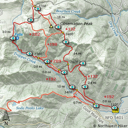
This all in compassing hike begins at
the trail head on Forest Road #5401.
The trail is fairly level for the first
3/4 miles then after reaching the junction
of Trail #132, you begin a steady climb.
You will follow this trail all the way
to the backside of Observation Peak where
you will then rejoin Trail #192.
The first couple miles of this hike
are through dense Old Growth forest
and are a delight to walk among the
giants. As the trail gains elevation
the size of the trees decrease. At
about 2.5 miles you will have gained
enough elevation that you begin to
hike through occasional open ares
thus affording you of excellent view
of Soda Peaks and the Trapper Creek
valley below.
At about 3.5 miles you will come to
a junction of Trail #198. Bear right
and stay on Trail #132 as it cuts
across the north side of Observation
Peak. You will get additional glimpses
of the distant mountains and valley
along this part of the hike. The
trail continues another mile before
you come to the junction of Trail #132A,
which is the route to the top of
Observation Peak.
In another half mile you will come to
the junction of Trail #192. This is
the same trail on which you began
your hike. Follow this trail up
and around a small hill then begin
a steep descent into the Trapper
Creek Valley. In about a mile and
a half you will need to cross the
creek. There should be a suitable
log crossing above the small rapids.
The trail now begins to descend
steeper and steeper with each step.
Finally switchbacks will ease the
rate of descent. While working
your way down into the Trapper
Creek valley, you will come to an
obvious place where you can leave
the trail for just a few feet and
gain an excellent view of a waterfalls
on Trapper Creek.
At the bottom of all this descending
you will come to a substantial bridge
which crosses the creek and gets you
on your way down the valley paralleling
the creek as you go, but well above
it to the point you don't see it.
After another mile or so of hiking
you will come to an alternate route.
This is Trail #192A. Either way gets
you back to the same place as the
alternate route reconnects with the
original trail in about a half mile.
Ever since you crossed Trapper Creek
you will walk amongst the giants.
The Old Growth forest provides some
amazing specimens for your enjoyment.
Continuing on Trail #192 you will
eventually return to the junction of
Trail #132 where you left this trail
earlier. Just continue on #192 to
the trail head where you began this
hike.
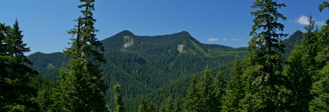
Soda Peaks as seen from the loop trail
|
How to get there:
NEW!
Click for PDF Directions Map of this Hike
From Portland, OR
From Portland, travel east on Interstate Hwy 84 to Exit 44 to Cascade Locks.
Exit the freeway and cross over the Columbia River into Washington
via the Bridge of the Gods. Then turn right, or east, and head
east through Stevenson, Washington to the intersection of the Wind
River Highway to Carson, Washington. Bear left onto the Wind River
Highway which will take you through Carson, Washington.
from Vancouver, WA
From Vancouver, WA travel east on SR14 through Stevenson, Washington to the
intersection of the Wind River Highway to Carson, Washington. Bear left onto the
Wind River Highway which will take you through Carson, Washington.
from Carson, WA
Continue north on the Wind River Highway (FR30) for about 8.6 miles to the
little community of Stabler and the junction with Forest Road 43, also called
Hemlock Road. Continue northwest on FR30 for another 5.4 miles and you will
pass a fish hatchery on the left. Continue on another half mile and you
will come to the junction with Forest Road 3065, which continues straight ahead.
Continue straight ahead on Forest Road 3065. After crossing
the Wind River you will come to the junction of Forest Road 5401. Turn right onto
FR5401 and cross Trapper Creek and drive a short distance to the parking area and
trailhead for this hike.
|