Hike 55
The Gifford Pinchot National Forest
Whistle Punk Trail Hike
Search North Goats Central Adams SE Hikes SW Hikes St Helens
Home Page
Main Map


Click to view product details

THE FOLLOWING MAP IS NOT TO BE USED FOR NAVIGATIONAL PURPOSES.
Map of the Whistle Punk Trail Hike

Length: 1.5 Miles round trip
Elevation Change: Almost No Elevation gain/loss
Season: Year Round
Difficulty:   Easy
Permit:   NW Forest Pass Required
Features:


NEW!
 Click for PDF Topo Map of this Hike 

This is a Universal Access Trail hike. It is almost level and wheel chair capable. The entire trail system is only 1.5 miles. There a several benches to rest on. And there are a number of signs explaining the uniqueness of a logging community and operation.

This hike is just off Forest Road 43 at the end of FR 417. The hike is only a half mile from the Bunker Hill hike.

Next to this interpretive trail is located the Wind River Canopy Crane Research Facility. The crane itself can be seen from this trail. The purpose of this project is to enable researchers to investigate the environment at and near the top of the old growth forest which surrounds the crane.


Whistle Punk trailhead in the Gifford Pinchot National Forest
Whistle Punk trailhead
How to get there:

NEW!
 Click for PDF Directions Map of this Hike 

From Portland, OR
From Portland, travel east on Interstate Hwy 84 to Exit 44 to Cascade Locks. Exit the freeway and cross over the Columbia River into Washington via the Bridge of the Gods. Then turn right, or east, and head east through Stevenson, Washington to the intersection of the Wind River Highway to Carson, Washington. Bear left onto the Wind River Highway which will take you through Carson, Washington.

from Vancouver, WA
From Vancouver, WA travel east on SR14 through Stevenson, Washington to the intersection of the Wind River Highway to Carson, Washington. Bear left onto the Wind River Highway which will take you through Carson, Washington.

from Carson, WA
Continue north on the Wind River Highway (FR30) for about 8.6 miles to the little community of Stabler and the junction with Forest Road 43, also called Hemlock Road. Turn left onto FR43 and cross a bridge over the Wind River and continue west for a couple of miles to the junction of FR43 and Forest Road 417. 
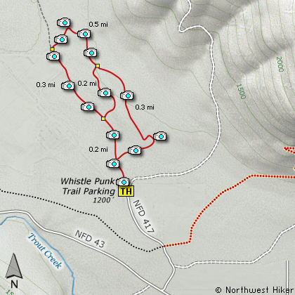
Turn right onto FR417 and follow it but a short distance to the end and the trailhead for this hike.


Hike Difficulty Calculator

Calorie Burn Calculator

The 10 Essentials
Bear Encounters

Cougar Encounters

River Crossing Safety
A Virtual Hike in the Gifford Pinchot National Forest


Click to View Instructions
le="Click for Larger Image" onMouseOver="doButtons('id14')"> Click to View Instructions