Length: 6.5 Miles round trip
Elevation Change: 900' Cumulative Elevation gain
Season: Late Spring thru Late Fall
Difficulty: Moderate
Permit: NW Forest Pass Required
Volcano Alert
Call this number to see if this trail is closed:
360-449-7800
Features:
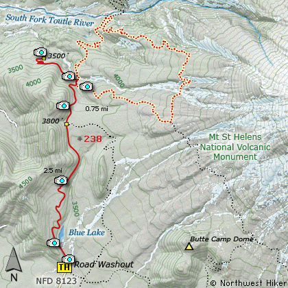
Because Forest Road 8123 is washed out, the
trail head to Sheep Canyon has to begin at
this point. For this CD I just hiked to the
canyon and did not do the loop up the canyon
and over to the South Fork of the Toutle
River and back.
Take note that crossing Coldsprings Creek can
be a challenge, and it might be a good idea to
carry a pair of sneakers with you to use to
cross the stream. That way your boots stay
dry, and probably you will stay dry by not
slipping off a log or rock and falling into
the creek.
The advantage to hiking to Sheep Canyon
from this location is you get to enjoy
Blue Lake along the way. As you approach
Blue Lake from a distance, it really looks
blue. However, when you get to the lake,
the color turns to a brilliant green.
After your visit to this small lake,
keep on Trail #238 and continue on to
Sheep Canyon.
After Blue Lake, the trail gets a lot
steeper. There are a couple switchbacks
that make the climb much easier. Most
of the first 2 miles of this hike are
through dense forest. At about 2 miles
you begin to catch views of Mt St Helens.
At about 2.5 miles you will come to the
junction of Trail #237, which can be an
alternative route back to the trail head
where you began. However, at this point,
keep straight ahead. This is also the
high point in the hike. So, now you begin
to descend.
The trail drops about 300 feet as it enters
Sheep Canyon.
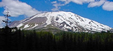
Mt St Helens as seen from the Sheep Canyon trail
|