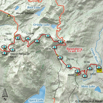
Length: 11.4 Miles round trip
Elevation Change: 2400' Cumulative Elevation gain
Season: Mid-Summer thru Mid-Fall
Difficulty: Difficult
Permit: NW Forest Pass Required
GPS: N46 18.27 W122 4.914
Latitude: 46.3045
Longitude: -122.0819
Volcano Alert
Call this number to see if this trail is closed:
360-449-7800
Features:
Here is a long hike with more beauty than
the human eye can absorb. The hike is
listed as difficult due to the elevation
gain and length. In season this hike
offers great floral displays. The hike
begins at the Norway Pass Trail Head.
The trail is steep during the first
mile as it gains nearly 900 feet. As
the trail climbs your views of the
surrounding valleys, hills, and mountains
improve. At 1 mile you come to the junction
of Trail #227A. Bear right and continue
on Trail #1 toward Norway Pass.
In a little over another mile you will
gain elevation and then lose some. Views
of Mt Rainier improve dramatically. When
you reach Norway Pass, you come to the
junction of Trail #227 that leads back to
Independence Pass. After taking a million
photos or so of Mt St Helens, continue on
toward Mt Margaret.
The trail now begins to climb vigorously.
From now on you will be treated to
exceptional vistas of Mt Adams to the east.
There are adequate switchbacks so the climb
is not difficult. Views of Mt St Helens
keep getting better and better. At about
another mile you will come to the junction
with Trail #211 which leads to the lake
basin on the north side of the Mt Margaret
complex. Keep straight ahead on Trail #1.
In another mile you will begin to get views
looking north toward Mt Rainier, and the
lake basin below you. In season you may
be treated to various encounters with the
elk of the area... at least to their bugling.
If you hike here early in the summer, you
will encounter snow. If you hike here late
in the summer or early fall you will
encounter huckleberries by the billions.
In about another mile you will come to the
junction with the abandoned Trail #214 to
Mt Whittier. Keep on straight ahead with
Trail #1 toward Mt Margaret. In another
mile you will come to the spur trail which
leads to the top of Mt Margaret. Follow
this Trail #1F to the top and feast on the
unparalleled views.
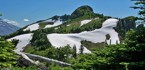
Mt Margaret peeks from behind an unnamed cliff
|
How to get there:
NEW!
Click for PDF Directions Map of this Hike
From Woodland, WA
From Woodland follow SR 503 and the Lewis River
Road for about 48 miles to the community of Cougar, WA. From Cougar, continue
east on the Lewis River Road which will turn into Forest Road 90 after you enter
the Gifford Pinchot National Forest. In about 18.5 miles you will come to the
junction of Forest Road 25. Forest Road 90 makes a right turn, downhill at this
junction, but you will need to continue straight ahead on what is now FR25.
Follow FR25 north for approximately 25 miles, passing the Cedar Flats Natural Area,
and the junction to Forest Road 93, which takes you to the Craggy Peak hike
and the Hat Rock Overlook hike, past Elk Pass and the junction of Forest
Road 28 which leads to the Craggy Peak hike, and finally you will come to
Forest Road 99 on your left, which is the road that leads to the
Windy Ridge side of the Mt. St. Helens National Volcanic Monument and many hikes.
From Carson, WA
If however, you plan to approach this hike from the Columbia River Gorge area, then
begin at Carson, Washington and head northwest on the Wind River Hwy. In 7.5 miles
you will pass through the little community of Stabler, and in another 5.8 miles you
will come to the junction of Forest Road 30. Turn right onto FR30 and follow this
road for 13.2 miles north along the Wind River and then up a steep incline and onto
a plateau where you will come to the junction of the Curly Creek Road. Turn left
onto the Curly Creek Road and follow it downhill past an excellent view area for
about 5.1 miles until you come to Forest Road 90. Turn left onto FR90 and follow
it for about 4.1 miles. You will descent to and cross the Lewis River then come to
the junction with Forest Road 25. Make a sharp right turn onto FR25.
Follow FR25 north for approximately 25 miles, passing the Cedar Flats Natural Area,
and the junction to Forest Road 93, which takes you to the Craggy Peak hike
and the Hat Rock Overlook hike, past Elk Pass and the junction of Forest
Road 28 which leads to the Craggy Peak hike, and finally you will come to
Forest Road 99 on your left, which is the road that leads to the
Windy Ridge side of the Mt. St. Helens National Volcanic Monument and many hikes.
From Randle, WA
Go south out of Randle on SR 131, cross the Cowlitz River, and you will come to
Forest Road 23 on your left. Stay on SR 131 heading south and soon this road
will become Forest Road 25. Continue south on FR25 for almost 20 miles and you
will come to Forest Road 99 on your right.
From junction of FR25 and FR99
After turning onto Forest Road 99, you will climb westward for about 9 miles before
coming to Forest Road 26 on your right, which takes your to the Norway Pass TH, which
is also the parking area for the Mt. Margaret hike.
|