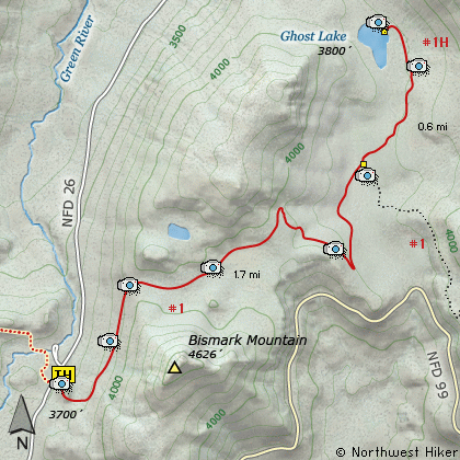
Length: 4.6 Miles round trip
Elevation Change: 500' Elevation gain/loss
Season: Summer thru Fall
Difficulty: Moderate
Permit: NW Forest Pass Required
Volcano Alert
Call this number to see if this trail is closed:
360-449-7800
Features:
This hike offers one of the very best
opportunities to see the devastation
of the Mt St Helens explosion in
comparative fashion. This hike
takes you from complete and total
devastation to virtual no devastation
and then back into almost complete.
The trail begins across Forest
Road #26 from the Norway Pass
Trail head. The trail climbs fairly
steep at first and at about a half
mile summits. While climbing to
this saddle, you are presented with
excellent views of the Mt Margaret
and Goat Mountain formations.
As you walk east of the saddle, you
will see Mt Adams peeking over the
distant tree covered ridge. The
steep cliffy area to your right, on
the south side of the trail is a
major player in why some of the forest
that you will be hiking through survived
the 1980 explosion.
At about a mile, you can walk off
trail for a few hundred feet to view
a small little pond. In season, this
is a very floral hike. Below you
is a nice meadow.
Now the trail descends a bit, and
enters a small stand of trees that by
fate, and a little help from the large
cliffy area to the south, survived the
explosion of Mt St Helens. This is a
very unique area to examine. You will
see trees with their tops missing, and
beside them, trees with their bark missing.
Then next to those trees you will see
trees that are completely unharmed.
The trail continues to descend and
finally crosses the stream from Ghost
Lake. The bridge may be out, but
the stream is small and not difficult
to cross. Immediately after the
stream is the junction to Ghost Lake
and Trail #1H.
It is another half mile to trails end
along side of the north end of Ghost
Lake. As you approach the lake, you
will wade through a considerable pile
of pumice left over from the 1980
event. All in all, this hike really
demonstrates the variety of effects
of the devastation.
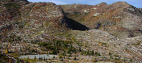
Looking back at the trailhead for the Ghost Lake trail
|
How to get there:
NEW!
Click for PDF Directions Map of this Hike
From Woodland, WA
From Woodland follow SR 503 and the Lewis River
Road for about 48 miles to the community of Cougar, WA. From Cougar, continue
east on the Lewis River Road which will turn into Forest Road 90 after you enter
the Gifford Pinchot National Forest. In about 18.5 miles you will come to the
junction of Forest Road 25. Forest Road 90 makes a right turn, downhill at this
junction, but you will need to continue straight ahead on what is now FR25.
Follow FR25 north for approximately 25 miles, passing the Cedar Flats Natural Area,
and the junction to Forest Road 93, which takes you to the Craggy Peak hike
and the Hat Rock Overlook hike, past Elk Pass and the junction of Forest
Road 28 which leads to the Craggy Peak hike, and finally you will come to
Forest Road 99 on your left, which is the road that leads to the
Windy Ridge side of the Mt. St. Helens National Volcanic Monument and many hikes.
From Carson, WA
If however, you plan to approach this hike from the Columbia River Gorge area, then
begin at Carson, Washington and head northwest on the Wind River Hwy. In 7.5 miles
you will pass through the little community of Stabler, and in another 5.8 miles you
will come to the junction of Forest Road 30. Turn right onto FR30 and follow this
road for 13.2 miles north along the Wind River and then up a steep incline and onto
a plateau where you will come to the junction of the Curly Creek Road. Turn left
onto the Curly Creek Road and follow it downhill past an excellent view area for
about 5.1 miles until you come to Forest Road 90. Turn left onto FR90 and follow
it for about 4.1 miles. You will descent to and cross the Lewis River then come to
the junction with Forest Road 25. Make a sharp right turn onto FR25.
Follow FR25 north for approximately 25 miles, passing the Cedar Flats Natural Area,
and the junction to Forest Road 93, which takes you to the Craggy Peak hike
and the Hat Rock Overlook hike, past Elk Pass and the junction of Forest
Road 28 which leads to the Craggy Peak hike, and finally you will come to
Forest Road 99 on your left, which is the road that leads to the
Windy Ridge side of the Mt. St. Helens National Volcanic Monument and many hikes.
From Randle, WA
Go south out of Randle on SR 131, cross the Cowlitz River, and you will come to
Forest Road 23 on your left. Stay on SR 131 heading south and soon this road
will become Forest Road 25. Continue south on FR25 for almost 20 miles and you
will come to Forest Road 99 on your right.
From junction of FR25 and FR99
After turning onto Forest Road 99, you will climb westward for about 9 miles before
coming to Forest Road 26 on your right, which takes your to the Norway Pass TH, which
is also the parking area for the Ghost Lake hike. After you park, you will walk back out
to FR99 and you will see the sign for the Boundary Trail 1, which will take for this hike.
|