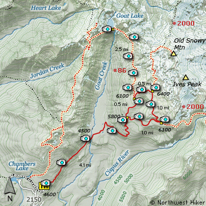
Length: 5 Miles round trip
Elevation Change: 400' Elevation gain
Season: Summer thru Fall
Difficulty: Moderate
Permit: NW Forest Pass Required
Volcano Alert
Call this number to see if this trail is closed:
360-449-7800
Note: This trail is often closed just beyond the overlook area.
Features:
Here is a little hike that has tons of beauty
for the buck.... in other words, lots of value
for little effort. This hike not only gives
you outstanding vistas, but allows you to
see close up just how devastating the explosion
of Mt St Helens really was. The hike begins along
Forest Road 99 and begins an immediate gentle
climb.
In a short distance the trail breaks over the
ridge and you are presented with excellent
views of Mt St Helens and Spirit Lake. In
the first half mile of this hike there are
a number of signs and explanation boards to
make your hike more interesting and informed.
Then the trail becomes more rustic and climbs
gently toward Independence Pass. At a mile
you will come to the junction of Trail #227A.
Continue on, bearing to the left as the trail
continues. Along this part of the trail,
you will be presented with outstanding views
of Mt St Helens, Spirit Lake, and even Mt Hood
in the far distance.
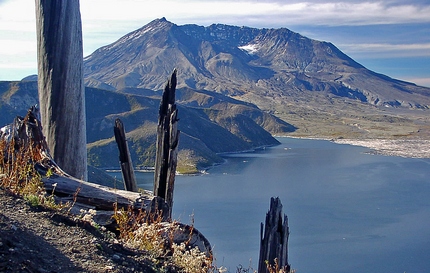
Mt St Helens rises above Spirit Lake
|
How to get there:
NEW!
Click for PDF Directions Map of this Hike
From Woodland, WA
From Woodland follow SR 503 and the Lewis River
Road for about 48 miles to the community of Cougar, WA. From Cougar, continue
east on the Lewis River Road which will turn into Forest Road 90 after you enter
the Gifford Pinchot National Forest. In about 18.5 miles you will come to the
junction of Forest Road 25. Forest Road 90 makes a right turn, downhill at this
junction, but you will need to continue straight ahead on what is now FR25.
Follow FR25 north for approximately 25 miles, passing the Cedar Flats Natural Area,
and the junction to Forest Road 93, which takes you to the Craggy Peak hike
and the Hat Rock Overlook hike, past Elk Pass and the junction of Forest
Road 28 which leads to the Craggy Peak hike, and finally you will come to
Forest Road 99 on your left, which is the road that leads to the
Windy Ridge side of the Mt. St. Helens National Volcanic Monument and many hikes.
From Carson, WA
If however, you plan to approach this hike from the Columbia River Gorge area, then
begin at Carson, Washington and head northwest on the Wind River Hwy. In 7.5 miles
you will pass through the little community of Stabler, and in another 5.8 miles you
will come to the junction of Forest Road 30. Turn right onto FR30 and follow this
road for 13.2 miles north along the Wind River and then up a steep incline and onto
a plateau where you will come to the junction of the Curly Creek Road. Turn left
onto the Curly Creek Road and follow it downhill past an excellent view area for
about 5.1 miles until you come to Forest Road 90. Turn left onto FR90 and follow
it for about 4.1 miles. You will descent to and cross the Lewis River then come to
the junction with Forest Road 25. Make a sharp right turn onto FR25.
Follow FR25 north for approximately 25 miles, passing the Cedar Flats Natural Area,
and the junction to Forest Road 93, which takes you to the Craggy Peak hike
and the Hat Rock Overlook hike, past Elk Pass and the junction of Forest
Road 28 which leads to the Craggy Peak hike, and finally you will come to
Forest Road 99 on your left, which is the road that leads to the
Windy Ridge side of the Mt. St. Helens National Volcanic Monument and many hikes.
From Randle, WA
Go south out of Randle on SR 131, cross the Cowlitz River, and you will come to
Forest Road 23 on your left. Stay on SR 131 heading south and soon this road
will become Forest Road 25. Continue south on FR25 for almost 20 miles and you
will come to Forest Road 99 on your right.
From junction of FR25 and FR99
After turning onto Forest Road 99, you will climb westward for about 9 miles before
coming to Forest Road 26 on your right, which takes your to the Norway Pass TH and
the Goat Mtn TH. You continue on for a very short distance, and you will pass the
trailhead for the Meta Lake hike. Continue along FR99 for about 3 miles and you will
pass the trailhead for the Independence Pass hike.
|