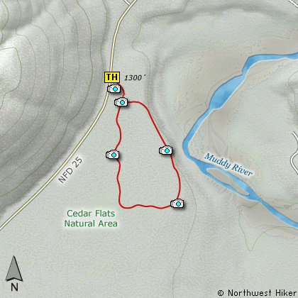
Length: 1 Mile Loop
Elevation Change: Very Little Elevation gain/loss
Season: Year Round
Difficulty: Easy
Permit: No Pass Requirement
Features:
Cedar Flats Natural Area is a preserve set aside
to protect an excellent collection of 650 year
old trees along the Muddy River. There are Western
Red Cedar, Douglas Fir, and Western Hemlock.
The trail provides a small loop through these
ancient trees where you can walk, and see,
and smell, and feel what it must have been
like in this valley so very long ago.
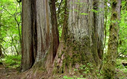
Old growth forest in the Cedar Flats Natural Area
|
How to get there:
NEW!
Click for PDF Directions Map of this Hike
From Woodland, WA
From Woodland follow SR 503 and the Lewis River
Road for about 48 miles to the community of Cougar, WA. From Cougar, continue
east on the Lewis River Road which will turn into Forest Road 90 after you enter
the Gifford Pinchot National Forest. In about 18.5 miles you will come to the
junction of Forest Road 25. Forest Road 90 makes a right turn, downhill at this
junction, but you will need to continue straight ahead on what is now FR25.
It is about 3.6 miles from this junction to the parking area along FR25 for the
Cedar Flats Natural Area.
From Carson, WA
If however, you plan to approach this hike from the Columbia River Gorge area, then
begin at Carson, Washington and head northwest on the Wind River Hwy. In 7.5 miles
you will pass through the little community of Stabler, and in another 5.8 miles you
will come to the junction of Forest Road 30. Turn right onto FR30 and follow this
road for 13.2 miles north along the Wind River and then up a steep incline and onto
a plateau where you will come to the junction of the Curly Creek Road. Turn left
onto the Curly Creek Road and follow it downhill past an excellent view area for
about 5.1 miles until you come to Forest Road 90. Turn left onto FR90 and follow
it for about 4.1 miles. You will descend to and cross the Lewis River then come to
the junction with Forest Road 25. Make a sharp right turn onto FR25.
It is about 3.6 miles from this junction to the parking area along FR25 for the
Cedar Flats Natural Area.
|