

|
THE FOLLOWING MAP IS NOT TO BE USED FOR NAVIGATIONAL PURPOSES.
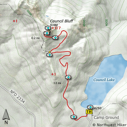
Map of the Council Bluff, Council Lake Hike
|
Length: 3 Miles round trip
Elevation Change: 800' Elevation gain
Season: Summer thru Fall
Difficulty: Moderate
Permit: NW Forest Pass Required
GPS: N46 15.792, W121 37.896
Latitude: 46.2632
Longitude: -121.6316
Features:
This hike begins at the Council Lake
campground off Forest Road #016 which
is just a short distance from FR #23.
Be sure to enjoy Council Lake before
or after your hike up Council Bluff.
The first mile of this hike follows an
old road. Be aware that motor bikes
are allowed on this stretch of the trail.
All of the first mile of this hike is
within dense timber with only a rare
glimpse out at Mt Adams or Council
Lake below.
At about a mile you will come to the
junction of Trail #117 which is the
foot only trail to the top of Council
Bluff. At this point you break out of
the dense forest and are out in the
open. Now you get to see why this
little hike is so worth it.
The trail begins on the east side of
the bluff then works its way around
the south side and approaches the
top from the southwest.
The rewards for reaching the top of
Council Bluff are in the magnificent
views. Mt Rainier, the Goat Rocks,
Mt Adams, Mt Hood, and of course
Mt St Helens (but not from summit).
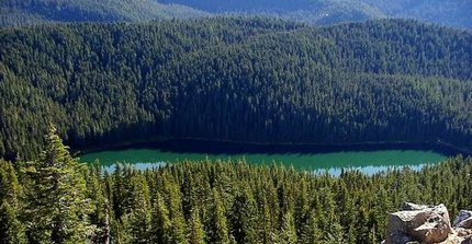
Council Lake as seen from Council Bluff
|
How to get there:
NEW!
Click for PDF Directions Map of this Hike
From Portland, OR
From Portland, travel east on Interstate Hwy 84 to Exit 64 at Hood River.
Turn left, and pass under the freeway and cross the toll bridge ($2.00)
into Washington state. Turn left onto SR14 and drive approximately 1.5
miles to state road 141 Alt. Turn right onto SR141 Alt. and follow it another
2 miles and merge bearing left onto SR141. Then travel north on SR141
for another 19 miles to Trout Lake and the junction to Mt. Adams Road. Bear
right and forward onto Mt. Adams Road for about 1.3 miles and you
come to the junction with Forest Road 23. Bear left and ahead
onto FR23 and continue north for about 19 miles and you will come
to the junction with Forest Road 90. Take a sharp right uphill turn
and continue on FR23. At this point the road becomes very rough
surface and you will follow this road for just under 3 miles. You
then come to the junction of Forest Road 2334. Turn left onto FR2334
and follow it for a mile and a half to Forest Road 016 that leads
straight ahead to the campground at Council Lake. Park in an appropriate
place above the lake. The trail begins as an old abandoned road.
|
|
|
A Virtual Hike in the Gifford Pinchot National Forest


|
|


