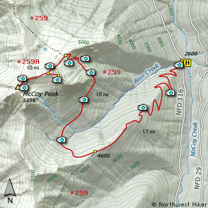
Length: 8 Miles round trip
Elevation Change: 3300' Elevation gain / 200' loss
Season: Mid-Summer thru Fall
Difficulty: Very Difficult due to steepness and Shape of trail
Permit: NW Forest Pass Required
Features:
This hike begins off Forest Road #115 which is just
off FR #29. Be aware that this trail allows motorized
bikes and the trail is V shaped as a result. On
the day I hiked it I did not see or hear any bikes.
This hike is one of the steepest hikes I've ever
encountered. In the first mile and a half you
gain almost 2000 feet. There are lots of switchbacks,
about 8 major ones in the first mile. The hike
is in dense young forest for the first 1.5 miles.
Then you break out into the open for a brief look
at the surrounding terrain. Here you get an outstanding
view of Mt Rainier to the north, and of the McCoy
Creek Valley below.
The trail levels off at this point and soon
you reach the junction of Trail #283 with #259.
Bear right on Trail #259. The trail loses
elevation for about a quarter mile and crosses
a small stream with very muddy banks.
The trail begins a slow climb from the creek around
the base of McCoy Peak as it works its way to the
north side of the mountain. Gradually the trail
becomes steeper and steeper. Also the trail becomes
more and more in the open and the views increase
accordingly.
At about 3 miles from the trail head the trail reaches
the summit of a saddle between McCoy Peak and the
uplift to the north of it. It is at that point you
need to search for the obscure trail that will lead
you to the top of McCoy Peak.
This mile long trail will gain nearly 700 feet as
it works its way up the north and northwest sides
of the mountain. At times the trail is clearly
visible. At times it is difficult to follow.
The trail comes out on the western ridge of
McCoy Peak which runs to the southwest.
It is a great hike to follow this ridge line to
its end where you get absolutely wonderful views
of all the surrounding mountains; Mt Rainier,
Mt Adams, Mt Hood, Mt St Helens and all the
other less prominent peaks. In season the last 2
miles of this hike are a flower garden.
To reach the actual legitimate summit of
McCoy Peak, follow the ridge back to where
the trail leveled out and look to the east
northeast. The bare rocky summit is clearly
visible and just a short walk away. Again,
you are rewarded for your efforts.
The V shape of much of this trail may lead
you to be more exhausted that you might
expect from such a climb. In my opinion
it is still worth it.
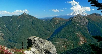
Mt Adam rises behind Juniper Ridge as seen from the McCoy Peak trail
|
How to get there:
NEW!
Click for PDF Directions Map of this Hike
From I-5 junction with US Hwy 12
Travel east on US Hwy 12 for about 48 miles to Randle.
From Randle, travel south on State Road 131, crossing the Cowlitz River and in a mile
you will come to Cispus Road on your left. Bear left and follow Cispus Road, which become
Forest Road 23, for another 5.2 miles and you will pass Forest Road 55 on your left.
Continue on FR23 for another mile and you will pass Forest Road 083 on your left, which
is the road to Layser Cave. But you keep straight ahead on FR23 for another 1.9 miles.
You will then come to the junction of Forest Road 28. Turn right on FR28 and cross the
Cispus River. A mile from SR23 you will come to the junction of Forest Road 29.
Continue south on SR29 for another 3.7 miles and you will come to Forest Road 2904 on
your left. But just keep driving south on FR29 for another 6.5 miles until you come to
Forest Road 115 on your right. Bear right and follow FR115 down a steep incline and
across a bridge to the trailhead for this difficult hike.
|