

|
THE FOLLOWING MAP IS NOT TO BE USED FOR NAVIGATIONAL PURPOSES.
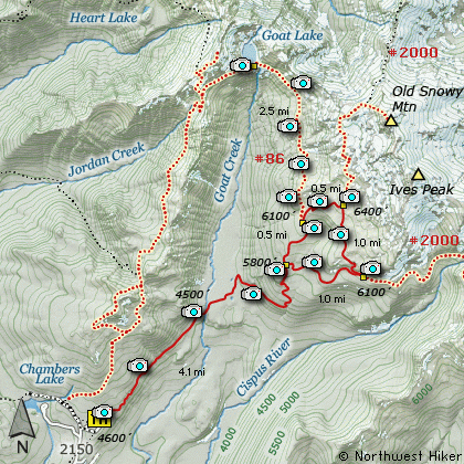
Map of the Nannie Ridge, Sheep Lake, PCT, Walupt Lake
|
Length: 14.8 Mile Loop
Elevation Change: 2100' Elevation gain / 200' loss
Season: Mid-Summer thru Fall
Difficulty: Difficult due to length
Permit: NW Forest Pass Required
Features:
The Hike to Sheep Lake via Nannie Ridge begins just east of the
campground at Walupt Lake. The trail is very steep at first and
gains about 2000' in the first 2 miles. Most of the first 2
miles is in dense forest with very few views.
At about 2 miles the trail passes over the crest of a spur
ridge of Nannie Ridge and one can hike directly to the top
of Nannie Peak from this point. However, you continue to
follow Trail #98 to go to Sheep Lake or the junction to the
Pacific Crest Trail #2000.
After passing the crest of the ridge, the trail drops a couple
hundred feet in elevation as it follows Nannie Ridge to the
northeast. From this point on you will be presented with
many fabulous vistas. In season the trail is lined with a
wonderful display of wildflowers.
At 4 miles you will come over the crest of a small ridge
and Sheep Lake will be directly below you. Keep you eye
open for mountain goats. I have seen many over the years
in the Goat Rock Wilderness, and even though I didn't see
any on my hike to Sheep Lake, signs of them were all around.
Sheep Lake is in a beautiful setting, regardless of what
season you have chosen to hike here. This hike is well
worth the effort.
There is an alternative return hike available. If you
continue on past Sheep Lake, you will come to the PCT #2000.
Bear right on the trail and follow it back south toward
for about 5 miles where you will intersect Trail #101.
You can follow this trail back to the parking area where
you began the hike. It is about 4.5 miles from the PCT to
the parking lot at Walupt Lake.
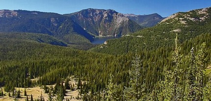
Walupt Lake from the Pacific Crest Trail
|
How to get there:
NEW!
Click for PDF Directions Map of this Hike
From I-5 junction with US Hwy 12
Travel east on US Hwy 12 for about 48 miles to Randle.
From Randle travel east on US Hwy 12 for about 13.3 miles to the junction with
Forest Road 21. Turn right (south) onto FR21 and follow it uphill for about 5 miles.
At this point you will see Forest Road 2110 on your left, which is the road to the
Glacier Lake trailhead, but you continue straight ahead on FR21. In another 8.1 miles
you will come to the junction of Forest Road 2150, which is the road to the Berry Patch
trailhead and many hikes in the heart of the Goat Rock Wilderness. Nevertheless, you
continue straight ahead on FR21 for another 2.9 miles. Here you will come to the
junction of Forest Road 2160. Bear left onto FR2160 and follow it across the creek
and up a steep hill for another 5.2 miles to Walupt Lake. There is a campground on
the northwest shore of the lake, and the trailheads are at the far east end.
|
|
|
A Virtual Hike of the Goat Rocks Wilderness Area


|
|


