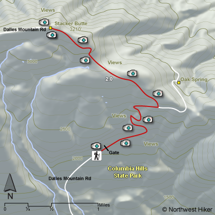
Length: 4 miles round trip
Elevation Change: 1120'
Season: Late winter thru late fall
Difficulty: Moderate
Permit: $10/day $30/yr Discover Pass Required
GPS: N45 41.694, W121 5.556
Latitude: 45.6949
Longitude: -121.0926
Features:
The Columbia Hills Natural Area Preserve is the largest NAP
in the state of Washington with 3600 acres. It was established
in 1993 to protect three rare plants: the obscure buttercup,
the Douglas draba, and the hot-rock penstemom.
There is a road hike available at this preserve and it is definately
worth the walk. The trailhead is located about a half mile above
an area called the Dalles Mountain Ranch. The road is gated at
this point and you simply walk up the road in a treeless open
environment. In April and May this area is dripping in wildflowers.
The most common are the Balsamroot and the Lupine. But there are
lots of other species to enjoy and photograph.
One of the highlights to climbing to the 3200 foot summit of this mountain
is the fantastic view of Mt. Adams to the north and Mt. Hood
to the south. There are a number of electronic devices on
this mountain, but they pose no problem to great vistas and
great photos. Use care while hiking in the warmer seasons as
there are rattlesnakes in this area. Also keep in mind that
this area is repleat with ticks. So, use appropriate precautions.
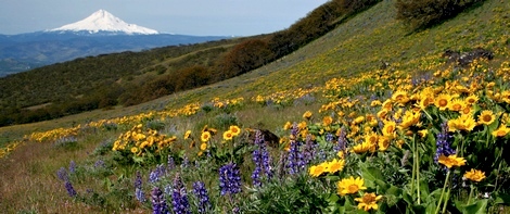 Stacker Butte trail view of Mt Hood
|
|
How to get there:
In Oregon, drive east or west on I-84 and take exit #87. Drive north on US 197 across the Columbia River Bridge.
Continue north about 2.5 miles to WA Hwy 14. Turn right heading east for approx. 1/2 mile to milepost #84. Turn
left/north onto gravel Dalles Mountain Road. Travel 3.2 miles to a fork in the road where there is an old wagon.
Turn left. Continue 1.3 miles until a gate blocks the road. Park here.
In Washington, drive east or west on WA Hwy 14 along the Columbia River. At milepost #84, turn north onto gravel
Dalles Mountain Road. Travel 3.2 miles to a fork in the road where there is an old wagon. Turn left. Continue 1.3 miles
until a gate blocks the road. Park here.
|