Length: 3.4 mile round trip
Elevation Change: 1000' gain
Season: May 1st through Halloween
Difficulty: Moderate
Permit: Pass Not Required
GPS: N45 40.9554, W121 18.039
Latitude: 45.68259
Longitude: -121.30065
Features:
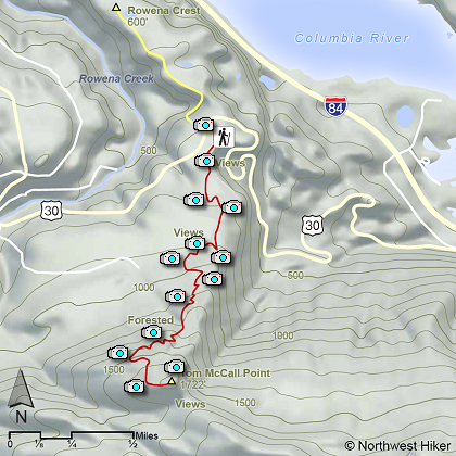
This excellent hike begins at the Rowena Overlook on the Old
Columbia River Highway between Hood River and The Dalles.
You can hike this trail almost any day of the year. Of course,
in the winter that could be a challenge. However, from March
thru October this hike provides you with a wonderful variety
of landscapes to enjoy.
Parking at the Rowena Overlook, you find the trail on the south
side of the area and follow it to the top of McCall Point. The
trail is fairly level at first, but then climbs steeper and steeper
as you work your way up Tom McCall Point.
This area is most famous for its spring floral displays. Wildflowers
begin showing themselves as early as late February, and by March are
in full swing. They just keep getting better and better with each
month, until they peak out by the end of June.
The views as you climb Tom McCall Point are nearly as wonderful as the
floral displays. The trail can be slick if it is wet, so be aware.
 Tom McCall Point
|