Length: 8
miles round trip
Elevation Change: 600' gain
Season: Year Round
Difficulty: Moderate due to length of hike
Permit: NW Forest Pass Required
GPS: N45 39.042, W121 56.07
Latitude: 45.6507
Longitude: -121.9345
Features:
A great
hike that is available nearly every day of the year. There are
times when the gorge is iced-in and none of the hikes are available,
but for the most part, one can hike this trail any time.
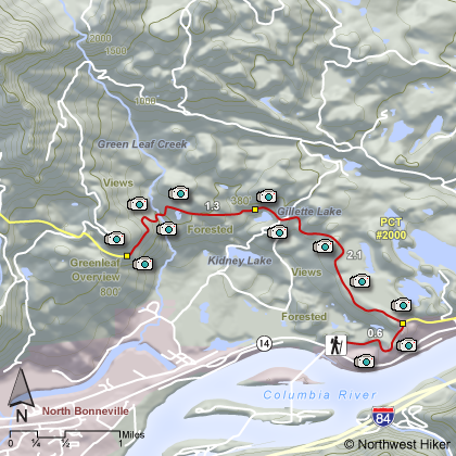
Beginning at the Bonneville Dam Trail head, the hike heads east to
hookup with the popular Pacific Crest Trail. Following this
trail north the hike brings you to Gillette Lake, which is one of
many lakes formed by the incredible geological event that created
the Bridge of the Gods.
The north half of Table Mountain and
of Greenleaf Mountain fell into the gorge, creating the Bridge of
the Gods, and also creating opportunities for many small lakes to
form. After passing Gillette Lake, you cross a number of
streams and pass another lake on your way to Greenleaf
Overlook.
This point is a good destination in that you have a
good view of the Columbia River
Gorge and the surrounding features.
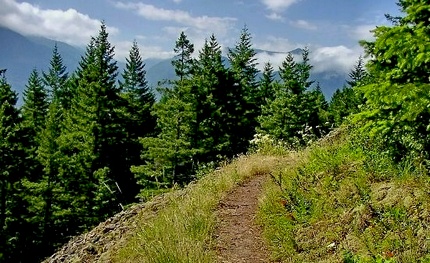 Greenleaf Overlook trail
|
|
How to get there:
Bonneville Trailhead: From Oregon, take I-84 to Exit #44/Cascade Locks. Follow the signs
to Bridge of the Gods/Stevenson and cross the bridge ($2 toll). Take a left and travel east
on WA Hwy 14 for about a mile and a half. After you see Bonneville Dam on your left, start
looking for the trailhead sign on your right.
From Vancouver, travel east on WA Hwy 14 for 35 miles. After you pass Beacon Rock State Park
and the town of North Bonneville, you'll see Bonneville Dam on your right. Just past the
dam on the left side of the highway is the Bonneville Trailhead.
|