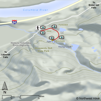
Hike 04
The Columbia River Gorge National Scenic Area
Sheppard's Dell Hike
Search West Hikes West Central East Central East Hikes
Home Page
Main Map


Click to view product details

THE FOLLOWING MAP IS NOT TO BE USED FOR NAVIGATIONAL PURPOSES. Shepperd's Dell hike map
Map of Shepperd's Dell hike

Length: 0.4 miles round trip
Elevation Change: 80' loss
Season: Year Round
Difficulty:    Easy
Permit: Not Required
GPS:   N45 32.910 W122 11.689
Features:


NEW!
 Click for PDF Topo Map of this Hike 

This short hike follows a paved trail downhill and around to an overlook of the Shepperd's Dell Waterfalls. One interesting point of this hike is the outstanding view you get of the old original bridge they built over this creek.

In season, which is spring to fall, there are alot of beautiful wildflowers along all of the gorge trails. Below is a photo of the evasive flower Robert Geranium.


The Roberts Geranium is an envasive species and not welcome in the gorge
The Roberts Geranium is an envasive species
and not welcome in the gorge

How to get there:

Shepperd's Dell Falls is located immediately off of the Historic Columbia River Highway, 4 miles east of Crown Point or about 1.75 miles west of Bridal Veil State Park. Parking can be found on the east side of the bridge, with a short trail leading to a viewpoint adjacent to the lower portion of the falls.


Hike Difficulty Calculator

Calorie Burn Calculator

The 10 Essentials
Bear Encounters

Cougar Encounters

River Crossing Safety
A Virtual Hike of the Columbia River Gorge National Scenic Area


Click to View Instructions