Introduction
The United States Congress designated the Mount Adams Wilderness in
1964 and it now has a total of 47,078 acres. All of this wilderness is
located in Washington and is managed by the Forest Service.
Description
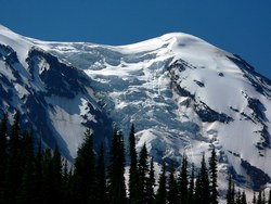
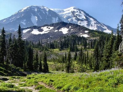 Second in height only to Mount Rainier statewide, 12,276-foot Mount Adams
looms over at least 10 impressive glaciers and a Wilderness of forested
slopes and subalpine meadows. The huge volcanic bulk of the mountain takes
up a considerable portion of the Wilderness and rises to its only peak. As
many as 25 climbing routes, from nontechnical to technically challenging,
provide access to this very popular summit. Elevation gain is approximately
7,000 feet. Approaching the mountain from the south you will find relatively
gentle terrain, a nice contrast for hikers in comparison to the treacherous
ice and sharp ridges on the west and the treacherous ice and vertical cliffs
on the east. The glaciated north face is less imposing. The eastern half of
the mountain lies within the Yakama Indian Reservation.
Second in height only to Mount Rainier statewide, 12,276-foot Mount Adams
looms over at least 10 impressive glaciers and a Wilderness of forested
slopes and subalpine meadows. The huge volcanic bulk of the mountain takes
up a considerable portion of the Wilderness and rises to its only peak. As
many as 25 climbing routes, from nontechnical to technically challenging,
provide access to this very popular summit. Elevation gain is approximately
7,000 feet. Approaching the mountain from the south you will find relatively
gentle terrain, a nice contrast for hikers in comparison to the treacherous
ice and sharp ridges on the west and the treacherous ice and vertical cliffs
on the east. The glaciated north face is less imposing. The eastern half of
the mountain lies within the Yakama Indian Reservation.
The Pacific Crest National Scenic Trail (PCT) crosses the Wilderness generally
north-south for about 21 miles on the west side of Mount Adams. Some 45 additional
miles of trails join the PCT, allowing you to hike about three-fourths of the way
around the base of Mount Adams.
Along the west slope of Mt. Adams lies the 47,280-acre Mt. Adams Wilderness. The 12,326-foot
high Mt. Adams is the second highest peak in the Northwest after Mt. Rainier.
Mt. Adams Wilderness is bounded on the east by the Yakama Indian Reservation.
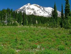
Wilderness trails offer the hiker spectacular views of Mt. Adams and its glaciers,
tumbling streams, open alpine forests and wildflowers scattered among lava flows
and rim rocks. Since the eruption of Mount St. Helens, Mt. Adams has become a popular
attraction for mountain climbers.
Here you'll find a unique blend of dry east side and moist west side weather
conditions which allow diverse types of vegetation to flourish. The area has a
complex geologic history that continues even today.
You can find active glaciers methodically carving away the mountain, and the
dramatic trace of avalanches that substantially altered the landscape. Even the
volcanic activity in the area is fairly recent: some occurred a mere 3,500 years
ago-bare moments on the scale of geologic time.
Taken all together, these qualities provide the visitor opportunities for a
rich and varied experience. We hope you enjoy your visit. Thanks for your help
in preserving the unique character of the Mount Adams Wilderness.
Climber's Guide
Many routes exist up Mount Adams with the South Climb route the most popular.
While these routes provide a wide range of difficulty, all mountain climbing,
whether a "walk up" or "technical climb", is a potentially
dangerous activity.
Click Here to view a USGS map of the glaciers on Mt. Adams.
All climbers need to be prepared to deal with a wide variety of weather, snow,
and rock conditions. Detailed information on climbing routes is available from
a number of climbing guidebooks. Consult these as you plan your trips. In addition
to the ten essentials for outdoor recreation (map and compass, whistle, flashlight,
extra food and water, warm clothing, a first-aid kit, sun glasses and sun screen,
waterproof matches, a candle or fire starter, and a pocket knife), equipment should
include sturdy hiking boots, ice ax, crampons, and ropes when travelling on glaciers.
For more information, see Mt. Adams
Climbing Permit Applicaion.
The Creation of Mount Adams
The mountain as we see it today is the result of volcanic activity and the
effects of glaciers on those volcanic deposits. The events listed below are among
the most dramatic (but certainly not the only!) events responsible for the shape
of Mount Adams as we know it today.
Among all the volcanic peaks in the Pacific Northwest, Mount Adams has a rich
and varied history. Adams lacks the symmetry which often characterizes volcanic
cones. Instead, it is a long ridge composed of a complex of several cones that
grew from volcanic flows occurring over successive ages.
- 450,000 years ago; oldest eruptions associated with mount Adams.
- 25,000 to 12,000 years ago; the period of most recent cone-building. The entire
mountain above timberline was constructed in a series of eruptions issuing at
the true summit, south summit, and Suksdorf Ridge.
- 21,000 to 12,000 years ago: the last major glacial expansion when ice covered
virtually the entire Wilderness. Tongues of glacial ice extended well down many
of the surrounding valleys. The glaciers smoothed and streamlined formerly rough
lava surfaces. These surfaces are now covered by deep glacial deposits or more
recent lava flows. The road to Morrison Creek and Cold Springs ascends one of
these glacier-formed ridges (also called moraines).
- 5,100 years ago: the Pinnacle was formed by a great avalanche. Sulfur gasses
(mostly hydrogen sulfide) combining with melt water from the ice cap created sulfuric
acid. This acidic melt water flowing from the summit, severely weakened the summit
rocks resulting in a dramatic avalanche. Debris from this avalanche flowed down
the White Salmon River to the Trout Lake Valley. The many large yellow-brown rubble
boulders around the valley are conspicuous reminders of this great avalanche.
- 3,500 to 6,000 years ago: the Muddy Fork and Aiken Lava Flows moved down the
flanks of Mount Adams, the latest-but probably not the last-volcanic activity
of Mount Adams.
- Twentieth century: in 1983 and 1921 large avalanches broke off the Avalanche
and White Salmon Headwall-the same headwall created by the great avalanche 5,100
years ago.
- The 1921 avalanche fell nearly one mile, covering almost 6,000 acres with
debris. Other avalanche deposits are prominent at Devils Garden, Avalanche Valley,
and along the Big Muddy below the Klickitat Glacier.
Permits
Remember, Wilderness Permits are required when you enter any wilderness area in the Gifford Pinchot National Forest.
Click Here for more information.
Rules
Click Here for PDF on Restrictions
Gifford Pinchot
Oh, by the way, who was Gifford Pinchot?
Click Here for more information.

