Search Northern Central Goat Rocks Mt Adams SE Hikes SW Hikes St Helens Hike List Return
Hike 87 Juniper Peak Main Menu
A PICTURE IS WORTH A THOUSAND WORDS MOVE MOUSE OVER MAP CAMERA ICONS TO VIEW PHOTOS - F5 TO REFRESH
MOVE MOUSE OVER TO VIEW QUICK-LINK MAP
CLICK ON ANY HIKE ICON TO JUMP TO THAT HIKE
Print Topo Map Hike Difficulty
Calculator
 
Legend Ten Essentials  

Hike Length: 6.5 miles round trip
Elev. Change: 2011' gain
Hike Difficulty: Challenging
Type of Hike: In and Out with sramble
Season: Summer thru Fall
Trail Numbers: #261
Trail Condition: Good
Trail Access: Good
Trail Signage: Good
Features: Views, Wildflowers
Pet Friendly: Yes
Useage: Moderate
Permit: NW FP NOT Required
Horses: Yes
Mtn Bikes: Yes

Summary:
Press CTRL + P to print. Photos do not show when you print this page. (Help)


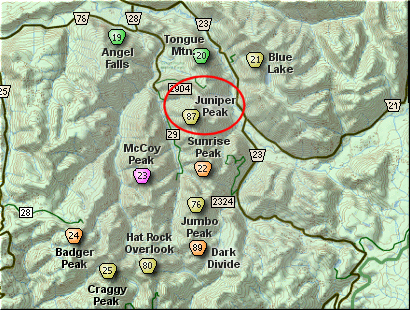
This hike begins on Forest Road #2904 at the trailhead for both Tongue Mountain to the north, and Juniper Ridge to the south.

To reach Juniper Peak, head south on Trail #261. This trail, as all others in this area, is open to motorized vehicles, so you will find the trail V shaped from the bike tires. Please be understanding and courteous to all bikers you encounter. This is the only area where they are allowed to enjoy their form of recreation.

The trail spends the first half of the distance to Juniper Peak working its way uphill through densely forested areas. In season, this entire hike can be a mosquito heaven.

About 2 miles into the hike and about 1500 feet higher, you will begin to break out of the dense forest and have spectacular views. It is the views that draw a hiker to this ridge and peak. In season this hike is a floral garden.

Hike to the far end of Juniper Peak itself before ascending, if only to enjoy the spectacular views in all directions. Once on top, you can choose any safe path back down to the trail and then return the route you came.


The following images are random samples of the wildflowers found in the Gifford Pinchot National Forest.
Mouseover image to view flower name, and click on image to jump to flower guide.

Directions:

From I-5 junction with US Hwy 12
Travel east on US Hwy 12 for about 48 miles to Randle. From Randle, travel south on State Road 131, crossing the Cowlitz River and in a mile you will come to Cispus Road on your left. Bear left and follow Cispus Road, which become Forest Road 23, for another 5.2 miles and you will pass Forest Road 55 on your left. Continue on FR23 for another mile and you will pass Forest Road 083 on your left, which is the road to Layser Cave. But you keep straight ahead on FR23 for another 1.9 miles. You will then come to the junction of Forest Road 28. Turn right on FR28 and cross the Cispus River. A mile from SR23 you will come to the junction of Forest Road 29. Continue south on SR29 for another 3.7 miles and you will come to Forest Road 2904 on your left. Turn left onto FR2904 and follow it up a steep and bumpy 4 miles to a saddle where you will see the Juniper Ridge trail crossing SR2904. Park here to hike to Tongue Mountain to the north or Juniper Peak to the south.


Click on the link below to see a map taking you to the trailhead.

Map Directions


Vicinity Map


To contact the Gifford Pinchot NF for current information: Click Here.


A Virtual Hike in the Gifford Pinchot National Forest
Click for PDF
Click for PDF