|
 |
| A PICTURE IS WORTH A THOUSAND WORDS |
MOVE MOUSE OVER MAP CAMERA ICONS  TO VIEW PHOTOS - F5 TO REFRESH TO VIEW PHOTOS - F5 TO REFRESH |
 |
 |
MOVE MOUSE OVER  TO VIEW QUICK-LINK MAP TO VIEW QUICK-LINK MAP
CLICK ON ANY HIKE ICON TO JUMP TO THAT HIKE |
|
|
|
| Hike Length: |
9.4 miles for all areas |
| Elev. Change: |
3000' gain |
| Hike Difficulty: |
Difficult |
| Type of Hike: |
Loop with GPS sramble |
| Season: |
Mid-Summer thru Fall |
|
| Trail Numbers: |
#10, 66 |
| Trail Condition: |
Good to non-existent |
| Trail Access: |
Good to poor |
| Trail Signage: |
None |
| Features: |
Views, Wildflowers, Lakes |
|
| Pet Friendly: |
Yes |
| Useage: |
Minimal |
| Permit: |
Yakama Nation Permit Required |
| Horses: |
No |
| Mtn Bikes: |
No |
|
|
Summary:
Press CTRL + P to print. Photos do not show when you print this page. (Help)
 PLEASE NOTE:
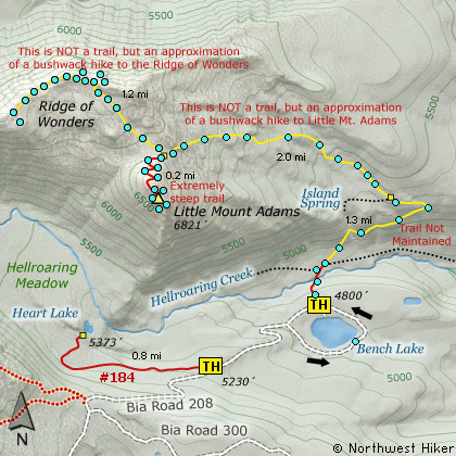
This is an unmaintained trail with
scrambles.
Much of the way with has no trail at all.
DO NOT ATTEMPT THIS HIKE UNLESS YOU ARE ENTIRELY
EQUIPPED AND EXPERIENCED FOR SUCH AN ADVENTURE.
Here is another fantastic gem located with the Yakama
Indian Reservation. Remember, a pass is required and
can be purchased along the road to Bench Lake.
At about 1/4 mile the trail drops steeply and crosses
Hellroaring Creek on a newly constructed bridge. The
trail begins to climb, but junctions shortly after the
bridge. Bear left and begin the steep climb to the
crest of the ridge.
At about 1.3 miles the trail passes a clearly visible
trail marker and it is at this point that I recommend
a cross-country scramble following the ridge line above
you.
Little Mt Adams is in sight almost all the time, so
it is not difficult to scramble your way below the
ridge you are following to the base of the mountain.
When you reach the base on the north side you will
see a trail that others have used to reach the summit.
Be sure to drop down into the crater itself and look
around for great vistas of Bench Lake, Heart Lake,
and of course Hellroaring Canyon and the gorgeous
Mt Adams which looms over you.

Ridge of Wonders sramble:
Anytime a person climbs Little Mt. Adams, it is almost
impossible to resist hiking over to the Ridge of Wonders
and discovering the incredible beauty and raw wonder
that this ridge provides.
There is kinda a user's trail from the base of Little
Mt. Adams over to the ridge, but even if it isn't obvious,
the trek over to the ridge is basically a common sense
scramble. I figure if you kinda follow the route indicated
on the map, it is about a mile and a quarter to the end of
the ridge, then if you just use Little Mt. Adams as a landmark,
you can just walk straight back to the mountain, cutting off
a bit of the original distance.
Another wonderful benefit for hiking over the ridge, is
the high likelihood that you will encounter mountain goats.
I've inserted a photo I took of some goats at another time
on the Ridge of Wonders, but they didn't pose very well, yet
you'll get the idea.

|
|
The following images are random samples of the wildflowers found in the Gifford Pinchot National Forest.
Mouseover image to view flower name, and click on image to jump to flower guide.
|
Directions:
From Portland, OR
From Portland, travel east on Interstate Hwy 84 to Exit 64 at Hood River.
Turn left, and pass under the freeway and cross the toll bridge ($1.00)
into Washington state. Turn left onto SR14 and drive approximately 1.5
miles to state road 141 Alt. Turn right onto SR141 Alt. and follow it another
2 miles and merge bearing left onto SR141. Then travel north on SR141
for another 19 miles to Trout Lake and the junction to Mt. Adams Road,
which heads north to other hike destinations.
from Trout Lake, WA
Bear right and forward onto Mt. Adams Road for about 1.3 miles and you
come to the junction with Forest Road 23.
Bear right and continue on Mt. Adams Road, which is also Forest Road 82,
for another half mile or so, and when you come to Forest Road 80, bear again
to the right and stay on FR82. To reach the Bird Creek Meadows area, just
stay on FR82 for another 8.3 miles past FR80. At this point, FR82 turns
into the Bureau of Indian Affairs Road 285 as well as FR8290.
Continue on BIA285 for another 4.2 miles and you will come to Mirror Lake
and the junction of BIA304 which takes you to Bird Lake. Continue another
mile and you will pass the parking area and trailhead for Bird Creek Meadows
on your left. BIA 208 now becomes extremely challenging, and heads down
a steep rough grade for about a mile and a half to the entrance of the
Bench Lake camping area. The road may be a one-way drive, so bear to your
right and drive around the lake to the obvious trailhead parking area on
the north side of the lake. As you drive around the lake, be sure to stop
for a moment and walk down to the lake and enjoy the incredible view of
Mt. Adams and Little Mt. Adams as seen from the lake.
Click on the link below to see a map taking you to the trailhead.
|
|
|
|
|
|
|
A Virtual Hike in the Gifford Pinchot National Forest

|

