Directions:
From Portland, travel east on Interstate Hwy 84 to Exit 44 to Cascade Locks.
Exit the freeway and cross over the Columbia River into Washington
via the Bridge of the Gods. Then turn right, or east, and head
east through Stevenson, Washington to the intersection of the Wind
River Highway to Carson, Washington. However, just continue east
on SR14 for another 8.8 miles and you will come to the Cook-Underwood
Road. Turn left onto this road and follow the signs to Willard, WA.
In about 6.7 miles you will drive through the quaint community of Willard.
Continue north and in about a half mile you come to a major junction. Bear
left onto Forest Road 66. Continue on FR66 past many spurs and side roads
for another 12 miles as you skirt a large lava bed to your left. Soon you
will come to what appears to be a side road that parallels FR66. This road
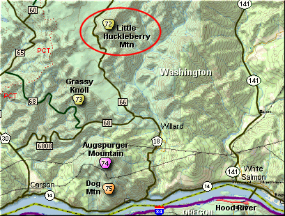
is the parking area for the trailhead to Little Huckleberry Mountain.
From Vancouver, WA travel east on SR14 through Stevenson, Washington to the
intersection of the Wind River Highway to Carson, Washington. However, just
continue east on SR14 for another 8.8 miles and you will come to the Cook-Underwood
Road. Turn left onto this road and follow the signs to Willard, WA.
In about 6.7 miles you will drive through the quaint community of Willard.
Continue north and in about a half mile you come to a major junction. Bear
left onto Forest Road 66. Continue on FR66 past many spurs and side roads
for another 12 miles as you skirt a large lava bed to your left. Soon you
will come to what appears to be a side road that parallels FR66. This road
is the parking area for the trailhead to Little Huckleberry Mountain.
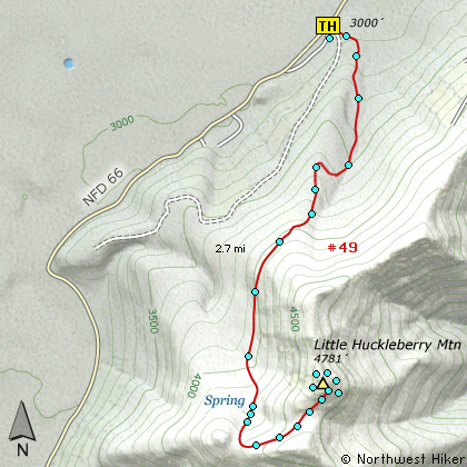
Click on the link below to see a map taking you to the trailhead.
|