Summary:
Press CTRL + P to print. Photos do not show when you print this page. (Help)
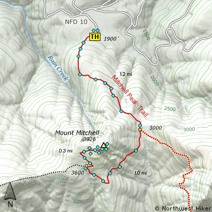
PLEASE NOTE THAT ACCESS TO THIS TRAILHEAD IS
RESTRICTED. AT THE TIME OF THIS PRINTING, IT WAS
NOT POSSIBLE TO GET THERE.
Even though this is a difficult hike
because of the rapid elevation gain,
it seems the most difficult part of
this hike was finding it. If it wasn't
for a pink ribbon tied around a tree,
I'm not sure if I would have found the
trail head.
As you drive up Forest Road 10, you
will come to several steep switchbacks,
then you will come to a level area where the
road seems to break into many pieces.
Take the first option to the right,
then keep straight ahead at the next
option. Watch for an old road on
your right, with a one car parking
area across the road on the left.
Walk up this old logging road just
a short distance, and then all of
a sudden there you are on a real
genuine trail!
Now that you've found the trail,
you will need to find the breath
to climb this very very steep trail.
In about a half mile, things level
off to a moderate climb and from
then on its not too bad.
About a mile into the hike, you
will cross a small stream whose
canyon allows you a great view of
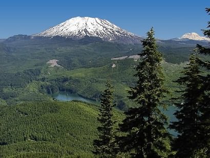
Mt St Helens just across the way.
A short while later you will come
to a junction of another approach
to Mount Mitchell. Keep straight
ahead.
Then you will begin to break out
into more open areas. Up until this
point you have been hiking in very
dense timber, but now you will be
more and more in the open. The
trail is making its way around the
south flank of the mountain for a
southwesterly approach. The floral
displays really begin to show, and
you are treated to great vistas of
points south.
After a couple steep switchbacks, you
will begin the final climb to the
top of Mount Mitchell. As you walk
the ridge line you are treated to
fantastic views of Mt St Helens to
the north, and Mt Hood to the south.
The top of Mount Mitchell is a large
rocky knob. The trail works its way
up this steep outcropping in such a
way that is not dangerous.
When you break out onto the top of
this peak, you are so rewarded for
your efforts that you may not even
notice the flood of perspiration
running down your face or your heart
about to exit your chest cavity.
Needless to say, this hike is a
real gem.
|