Volcano Alert
Click Volcanic Alert to discover if there are any current safety concerns.
Summary:
Press CTRL + P to print. Photos do not show when you print this page. (Help)

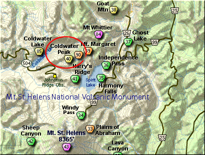
This superb hike begins at the northeast
corner of the Johnston Ridge parking lot.
The first 1/4 mile of the trail is paved
Visitors Center.
The trail follows Johnston Ridge eastward
in such a way that you get outstanding
views of Mt St Helens to the south,
Harry's Ridge to the east, and Coldwater
Peak to the north. The first 2 miles
of this hike are heavily used and have
rest benches from time to time. But
after about 2 miles, the traffic really
thins out.
At 2.3 miles you come to the junction
with Trail #207 that cuts over to
Windy Ridge. Keep straight ahead on
your Trail #1 (known as the Boundary
Trail). This is actually the low
point in the hike. From here on you
climb, gently at first, then quite
steeply later.
A little over 3 miles into the hike
you will cross a substantial metal
bridge just before the junction to
Trail #208 that leads to Harry's Ridge.
Keep straight and after crossing a
saddle area with excellent views of
Spirit Lake and Mt Adams to the east,
the trail climbs quite steeply for
the next mile.
The trail will take you to a ridge
where you can look down on St Helens
Lake and over to Mt Margaret. Mt
Rainier will be peaking over the
ridge to the north of the lake.
The trail follows around this
ridge then descends into an extremely
unique hole in the ridge.
The trail passes right through the
hole, or arch as some refer to it.
On the north side the trail skirts
the ridge and you can look down on
spectacular views of St Helens Lake.
In about a half mile you will come
to a major junction of trails.
At this point, keep on Boundary
Trail #1 which heads north along
the west side of St Helens Lake.
In about another 3/4 mile you will come
to the junction of Trail #1E. Bear
left and begin the steep, well
switch backed climb to the top of
Coldwater Peak. With every step you
gain better views of the surrounding
terrain, including Mt Adams to the
east, Spirit Lake, St Helens Lake,
and of course Mt St Helens itself.
From the top of Coldwater Peak you
get more excellent vistas to the
west and to the north where you can
see Mt Rainier.
|