|
 |
| A PICTURE IS WORTH A THOUSAND WORDS |
MOVE MOUSE OVER MAP CAMERA ICONS  TO VIEW PHOTOS - F5 TO REFRESH TO VIEW PHOTOS - F5 TO REFRESH |
 |
 |
MOVE MOUSE OVER  TO VIEW QUICK-LINK MAP TO VIEW QUICK-LINK MAP
CLICK ON ANY HIKE ICON TO JUMP TO THAT HIKE |
|
|
|
| Hike Length: |
9 miles round trip |
| Elev. Change: |
1000' gain |
| Hike Difficulty: |
Challenging |
| Type of Hike: |
In/Out with Loop |
| Season: |
Mid-Summer thru Fall |
|
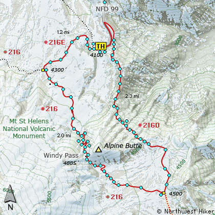
| Trail Numbers: |
#207, 216-E, 216, 216-D |
| Trail Condition: |
Good |
| Trail Access: |
Excellent |
| Trail Signage: |
Good |
| Features: |
Views, Wildflowers |
|
| Pet Friendly: |
Not Allowed |
| Useage: |
Light |
| Permit: |
NW FP Required |
| Horses: |
No |
| Mtn Bikes: |
No |
|
|
Volcano Alert
Click Volcanic Alert to discover if there are any current safety concerns.
Summary:
Press CTRL + P to print. Photos do not show when you print this page. (Help)
The road from the Windy Ridge Viewpoint is open
ONLY for research vehicles from Windy Ridge
to the trail head of the Windy Pass Trail,
therefore, this adds 3.5 miles RT to what
could have been a much shorter hike. But
such is the way of the Forest Service, and
one can only hope that some day that will
change. For now, park at the gated road
and hike along the roadway to the trailhead
for Trail #216E at the restricted parking
area.
This trail heads west as it gently
climbs toward the Loowit Trail #216,
which goes completely around Mt St Helens.
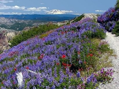
In season this part of the trail is
lined with unbelievably beautiful
floral displays.
When you reach Loowit Trail #216, bear
left and follow the trail uphill toward
Wind Pass. Looking north from the trail
you will be blessed with outstanding views
of Spirit Lake, Mt Margaret, Coldwater
Peak, and Mt Rainier to the north and
Mt Adams to the east.
As you approach Windy Pass, the trail
does a number of steep narrow switchbacks
When you reach Windy Pass you are
presented with incredible views of the
Plains of Abraham and vistas to the south
and southwest, including Mt Hood.
As you descend the ridge toward the
Plains of Abraham you will have exceptional
views of Mt Adams. Upon reaching the
plains, the trail crosses the level area
to the east to junction with Trail #216D.
Upon reaching this junction, bear left and
follow Trail #216D back to the trail head
where you began this hike.
During the wildflower season, this next
section of the trail is one of the most
floral and most beautiful anywhere! You
get alternating views of Mt Rainier and
Mt Adams.
As you approach the end of the trail,
you will encounter a very steep and very
unique stairway down this ridge. Use
caution at all times. The trail follows
the ridgeline to the road, which you
will need to follow back to the trail head
where you parked.
By the way, I actually did this loop starting
at the trailhead for Ape Canyon, all the
way to the Plains of Abraham, then the loop! Ugh.
|
|
The following images are random samples of the wildflowers found in the Gifford Pinchot National Forest.
Mouseover image to view flower name, and click on image to jump to flower guide.
|
Directions:
From Woodland, WA
From Woodland follow SR 503 and the Lewis River
Road for about 48 miles to the community of Cougar, WA. From Cougar, continue
east on the Lewis River Road which will turn into Forest Road 90 after you enter
the Gifford Pinchot National Forest. In about 18.5 miles you will come to the
junction of Forest Road 25. Forest Road 90 makes a right turn, downhill at this
junction, but you will need to continue straight ahead on what is now FR25.
Follow FR25 north for approximately 25 miles, passing the Cedar Flats Natural Area,
and the junction to Forest Road 93, which takes you to the Craggy Peak hike
and the Hat Rock Overlook hike, past Elk Pass and the junction of Forest
Road 28 which leads to the Craggy Peak hike, and finally you will come to
Forest Road 99 on your left, which is the road that leads to the
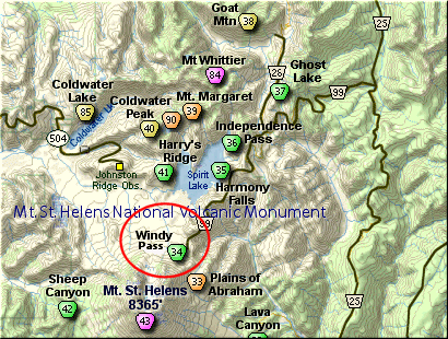
Windy Ridge side of the Mt. St. Helens National Volcanic Monument and many hikes.
From Carson, WA
If however, you plan to approach this hike from the Columbia River Gorge area, then
begin at Carson, Washington and head northwest on the Wind River Hwy. In 7.5 miles
you will pass through the little community of Stabler, and in another 5.8 miles you
will come to the junction of Forest Road 30. Turn right onto FR30 and follow this
road for 13.2 miles north along the Wind River and then up a steep incline and onto
a plateau where you will come to the junction of the Curly Creek Road. Turn left
onto the Curly Creek Road and follow it downhill past an excellent view area for
about 5.1 miles until you come to Forest Road 90. Turn left onto FR90 and follow
it for about 4.1 miles. You will descent to and cross the Lewis River then come to
the junction with Forest Road 25. Make a sharp right turn onto FR25.
Follow FR25 north for approximately 25 miles, passing the Cedar Flats Natural Area,
and the junction to Forest Road 93, which takes you to the Craggy Peak hike
and the Hat Rock Overlook hike, past Elk Pass and the junction of Forest
Road 28 which leads to the Craggy Peak hike, and finally you will come to
Forest Road 99 on your left, which is the road that leads to the
Windy Ridge side of the Mt. St. Helens National Volcanic Monument and many hikes.
From Randle, WA
Go south out of Randle on SR 131, cross the Cowlitz River, and you will come to
Forest Road 23 on your left. Stay on SR 131 heading south and soon this road
will become Forest Road 25. Continue south on FR25 for almost 20 miles and you
will come to Forest Road 99 on your right.
From junction of FR25 and FR99
After turning onto Forest Road 99, you will climb westward for about 9 miles before
coming to Forest Road 26 on your right, which takes your to the Norway Pass TH and
the Goat Mtn TH. You continue on for a very short distance, and you will pass the
trailhead for the Meta Lake hike. Continue along FR99 for about 3 miles and you will
pass the trailhead for the Independence Pass hike. Continue on FR99 for just over
another mile and you will pass the trailhead for the Harmony Falls hike. In about
5 more miles you will come to the end of this road and the parking area for the
Windy Ridge viewpoint. This is the same parking area for this hike to Windy Pass.
You will have to walk past a gate on what is still FR99, but visitors cannot drive
this portion of the road. You will have to hike along the road for almost 2 miles
before you will come to the actual trail.
Click on the link below to see a map taking you to the trailhead.
|
|
|
|
|
|
|
A Virtual Hike in the Gifford Pinchot National Forest

|

