Directions:
From Randle, WA
If you are coming from the north via Randle, Washington, you will want to head south
out of town on State Route 131. Continue south on this road, which will become
Forest Road 25 for the remainder of the journey. In just short of 20 miles you will
come to the junction of Forest Road 99, which leads to hikes along Windy Ridge and
the east side of Spirit Lake.
But for this hike, just continue south on FR25 for about 2 more miles and turn left, or east, onto
Forest Road 28. Follow FR28 for about 2.7 miles and then bear right onto Forest Road 2816.
You will then follow FR2816 another 4.4 miles to the trailhead for this hike.
From Woodland, WA
From Woodland follow SR 503 and the Lewis River
Road for about 48 miles to the community of Cougar, WA. From Cougar, continue
east on the Lewis River Road which will turn into Forest Road 90 after you enter
the Gifford Pinchot National Forest. In about 18.5 miles you will come to the
junction of Forest Road 25. Continue straight ahead on FR25.
Follow FR25 north then for about 23 miles, and you will then come to Forest Road 28 on
your right. Follow FR28 for about 2.7 miles and then bear right onto Forest Road 2816.
You will then follow FR2816 another 4.4 miles to the trailhead for this hike.
From Carson, WA
If however, you plan to approach this hike from the Columbia River Gorge area, then
begin at Carson, Washington and head northwest on the Wind River Hwy. In 7.5 miles
you will pass through the little community of Stabler, and in another 5.8 miles you
will come to the junction of Forest Road 30. Turn right onto FR30 and follow this
road for 13.2 miles north along the Wind River and then up a steep incline and onto
a plateau where you will come to the junction of the Curly Creek Road. Turn left
onto the Curly Creek Road and follow it downhill past an excellent view area for
about 5.1 miles until you come to Forest Road 90. Turn left onto FR90 and follow
it west for another 4.1 miles until you come to the junction of FR90 and FR25.
Turn right onto FR25.
Follow FR25 north then for about 23 miles, and you will then come to Forest Road 28 on
your right. Follow FR28 for about 2.7 miles and then bear right onto Forest Road 2816.
You will then follow FR2816 another 4.4 miles to the trailhead for this hike.
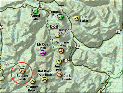
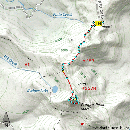
Click on the link below to see a map taking you to the trailhead.
|