| A PICTURE IS WORTH A THOUSAND WORDS |
MOVE MOUSE OVER MAP CAMERA ICONS  TO VIEW PHOTOS - F5 TO REFRESH TO VIEW PHOTOS - F5 TO REFRESH |
 |
 |
MOVE MOUSE OVER  TO VIEW QUICK-LINK MAP TO VIEW QUICK-LINK MAP
CLICK ON ANY HIKE ICON TO JUMP TO THAT HIKE |
|
|
|
| Hike Length: |
11 miles round trip |
| Elev. Change: |
4000' gain |
| Hike Difficulty: |
Very Difficult |
| Type of Hike: |
In and Out |
| Season: |
Mid-Summer thru Mid-Fall |
|
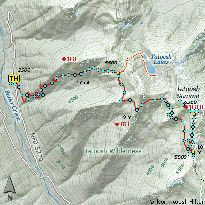
| Trail Numbers: |
#161, 161-A |
| Trail Condition: |
Good |
| Trail Access: |
Excellent |
| Trail Signage: |
Good |
| Features: |
Views, Wildflowers |
|
| Pet Friendly: |
Yes |
| Useage: |
Minimal |
| Permit: |
NW FP NOT Required |
| Horses: |
Yes |
| Mtn Bikes: |
Yes |
|
|
Summary:
Press CTRL + P to print. Photos do not show when you print this page. (Help)
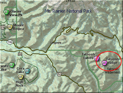
This hike uses the same trail head as the hike to Tatoosh Lakes. You begin
the climb off Forest Road 5270, and in the first 2.5 miles you gain almost
3000'. Then the trail breaks out into more open areas and at 3 miles you
come to the junction to Tatoosh Lakes.
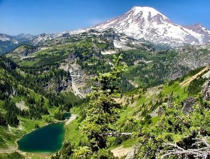
In season you will be treated to outstanding wildflower displays, and in
every season you will be treated to incredible vistas. After the junction
to Tatoosh Lakes the trail parallels the ridgeline for the next 2 miles.
Just a few feet before the trail crosses over the saddle of Tatoosh Ridge,
Trail #161A to the summit veers off to the left. The trail then switchbacks
its way up the ridgeline to the top of Tatoosh Ridge. From the summit
you are overwhelmed with vistas of Mt Rainier, Mt Adams, Mt St Helens and
the nearby Goat Rock Wilderness mountains.
|
|
The following images are random samples of the wildflowers found in the Gifford Pinchot National Forest.
Mouseover image to view flower name, and click on image to jump to flower guide.
|
Directions:
From I-5 junction with US Hwy 12
Travel east on US Hwy 12 for about 64 miles to Packwood.
As you eastbound on US Hwy 12 through Packwood, near the east end of the town, you will
come to the junction of Forest Road 52 on your left. Follow FR52 west across the Cowlitz River,
and uphill out of the valley for about 4.1 miles. You will then come to the junction with
Forest Road 5270 on your right. Bear right and follow FR5270 for about 5.6 miles where it
is just about to cross Butter Creek. Bear right onto Forest Road 5272 and follow this road
for about 1.4 miles and you will find the trailhead for both Tatoosh Wilderness hikes on your right.
Click on the link below to see a map taking you to the trailhead.
|
|


